
Geo-Fencing
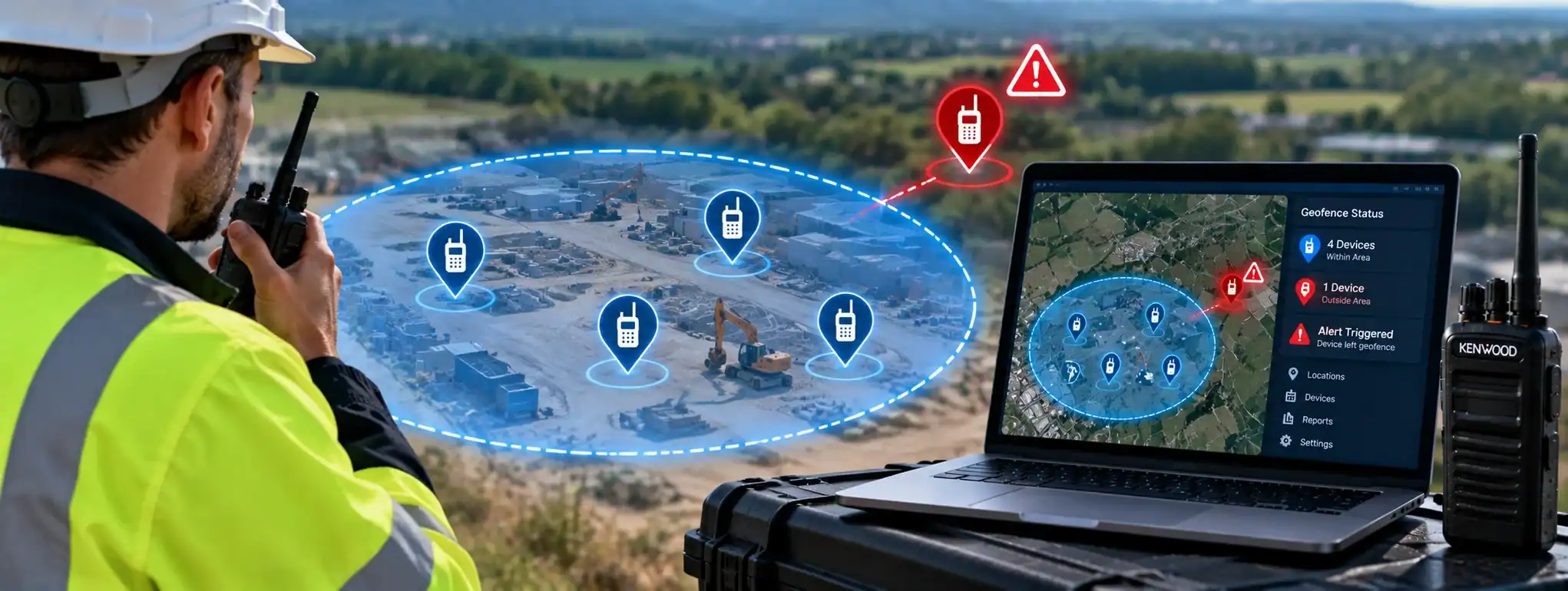
Geo-Fencing is a location-based feature that uses a defined geographical area, or virtual boundary, to trigger an action when a radio user or other tracked device enters or leaves that area.
In professional two-way radio systems, Geo-Fencing can be used alongside GPS and location-management software to monitor radio users and apply predefined rules to particular geographical areas.
For example, a radio systemA Radio System is a complete communication solution comprising two-way radios and, where required, equipment such as repeaters, antennas, base stations, mobile radios and network infrastructure. could define a restricted area around a site and generate an alert when a tracked radio enters or leaves the designated zoneA Zone is a group of programmed radio channels or talk groups organised within a two-way radio. Zones make it easier for users to find and switch between different communication services..
Geo-Fencing is commonly associated with professional radio systems used for security, transport, construction, logistics, events and other operations where knowing the location of personnel or equipment is useful.
How does Geo-Fencing work?
A Geo-Fence is created by defining a geographical boundary within compatible radio-management or dispatch software.
The system can then use location information from a radio or other device to determine its position relative to that boundary.
A simplified process is:
GPS location → Location compared with Geo-Fence → Boundary crossed → Configured action
The action taken depends on the capabilities of the radio system.
Geo-Fencing and GPS
Geo-Fencing normally relies on GPS or another supported location service to determine the position of the radio.
The radio periodically provides location information to the system, which compares that position with the defined geographical boundary.
If the radio enters or leaves the boundary, the system can respond according to its configuration.
The accuracy of Geo-Fencing therefore depends partly on the accuracy and availability of the location information.
What is a Geo-Fence?
A Geo-Fence is a virtual geographical boundary created within software.
It does not require a physical fence or barrier.
A Geo-Fence can be created around an area such as:
- Building
- Construction site
- Event venue
- Car park
- Transport depot
- Industrial site
- Restricted area
- Geographical operating zone
The shape and size of the boundary depend on the software being used.
Entering a Geo-Fence
A radio can be configured or monitored so that entering a Geo-Fenced area triggers a defined action.
Depending on the system, this could include:
- Generating an alert
- Sending a notification
- Recording an event
- Changing a radio setting
- Notifying a dispatcher
- Updating the user’s status
Not every radio system supports automatic actions when a Geo-Fence is entered.
Leaving a Geo-Fence
Geo-Fencing can also detect when a tracked radio leaves a defined geographical area.
For example, a business could establish an operating zone and receive an alert when a vehicle or radio user leaves that area.
This can be useful for monitoring operational boundaries or responding to unexpected movements.
Geo-Fencing and Dispatch
Dispatch systems can use Geo-Fencing to provide location-based alerts and operational information to dispatchers.
A dispatcher may be able to see radio users on a map and identify when a device crosses a predefined boundary.
The exact features available depend on the dispatch platform.
Geo-Fencing and Cloud Management
Modern Cloud ManagementCloud Management uses an online platform to remotely manage and monitor compatible two-way radios, users, devices and communication settings from a central location. platforms can provide Geo-Fencing through a web-based interface.
An administrator may be able to create, edit and manage geographical boundaries remotely.
Cloud-based systems can be particularly useful for organisations operating radio fleets across multiple sites.
Geo-Fencing and DMR
Professional DMR (Digital Mobile RadioA Mobile Radio is a two-way radio designed to be installed in a vehicle. It normally uses the vehicle's power supply and an external antenna to provide reliable communication while travelling or working in the field.) systems can incorporate GPS and location-management features where supported by the equipment and networkA Network is a connected system of radios, equipment and infrastructure that allows users to communicate across a defined area. Radio networks can range from simple radio-to-radio systems to large multi-site networks..
Geo-Fencing may then be provided through compatible dispatch or fleet-management software.
However, Geo-Fencing is not a standard feature of every DMR radio.
The radio, network and management platform must all support the required functionality.
Geo-Fencing and radio tracking
Geo-Fencing is closely related to Radio Tracking.
Radio tracking provides information about where a radio is located.
Geo-Fencing adds a geographical rule to that location information.
For example:
Radio tracking: “Radio 105 is currently here.”
Geo-Fencing: “Radio 105 has entered the restricted area.”
Geo-Fencing and Fleet Management
Fleet ManagementFleet Management is the process of managing a two-way radio fleet, including equipment, users, programming, maintenance, firmware, security and radio system configuration. systems can use Geo-Fencing to manage the location of radios and other mobile equipment.
This can help an organisation understand whether equipment is operating within its expected geographical area.
It can also provide alerts when equipment moves outside defined boundaries.
Geo-Fencing for security
Security organisations can use Geo-Fencing to monitor personnel or assets around defined areas.
For example, a security operation could establish a boundary around a restricted zone and receive an alert if a tracked radio enters or leaves that area.
This can provide an additional operational tool alongside normal security procedures.
Geo-Fencing for construction
Construction sites can change significantly during a project.
Geo-Fencing can be used to define the site’s operational boundary or specific restricted areas.
Where compatible location-enabled radios are being used, the system can provide location-based information to site management or control personnel.
Geo-Fencing for events
Large events can contain multiple operational areas.
Geo-Fences can potentially be used to define areas such as:
- Event site
- Backstage
- Restricted access areas
- Car parks
- Staff areas
- Emergency zones
Location-based alerts can help event control understand when tracked radios move between designated areas.
Geo-Fencing for transport
Transport and logistics organisations can use Geo-Fencing to define operating areas, depots, routes or restricted locations.
Where compatible GPS-enabled radios or devices are used, location events can be recorded or reported when vehicles or personnel cross defined boundaries.
Geo-Fencing and lone workers
Geo-Fencing can complement Lone WorkerA Lone Worker is someone who works without direct supervision or immediate assistance nearby. Compatible two-way radios can provide safety features such as timed check-ins, emergency alerts and GPS location. systems by providing additional information about where a lone worker is operating.
For example, an organisation may establish an approved operating area for a lone worker.
If the worker leaves that area, the system may generate an alert where the relevant functionality is supported.
Geo-Fencing should complement rather than replace established lone-worker procedures.
Geo-Fencing and emergency communications
Geo-Fencing can provide useful location information during an emergency.
For example, a dispatcher may be able to see that a radio user is within a particular defined area.
However, Geo-Fencing itself is not an emergency communication function.
Features such as Emergency CallAn Emergency Call is a priority two-way radio function that allows a user to quickly request assistance and, on supported systems, establish an urgent voice communication with a dispatcher or control room., Emergency AlarmAn Emergency Alarm allows a two-way radio user to quickly alert a dispatcher, control room or other authorised users that assistance may be required. and Man DownMan Down is a safety feature on some professional two-way radios that can detect a possible fall or unusual radio position and automatically raise an alert if the user does not respond. provide separate emergency capabilities.
Geo-Fencing and Man Down
Man Down detects conditions such as a radio being tilted or remaining stationary, depending on the system.
Geo-Fencing instead uses geographical location.
The two features can be combined where supported, providing both physical and location-based information about a radio user.
Geo-Fencing and radio alerts
A Geo-Fence can be configured to generate an alert when a defined location event occurs.
The alert may be presented to a dispatcher, administrator or other authorised user.
The exact alert mechanism depends on the software and radio system.
Geo-Fencing and channels
In some advanced radio systems, location can be used as part of a wider operational configuration.
For example, different geographical areas may have different communication requirements.
However, Geo-Fencing does not automatically change a radio’s channelA two-way radio channel is a programmed set of communication settings, typically including frequency and signalling, that allows compatible radios to communicate with one another. unless the specific system has been designed and configured to perform that action.
Geo-Fencing and talkgroups
Similarly, Geo-Fencing can potentially be integrated with Talkgroup management on systems that support location-based configuration.
For example, a system could potentially provide different operational communications depending on where a user is located.
This is a system-specific capability and should not be assumed to be available on every professional radio.
Geo-Fencing and radio hire
Geo-Fencing can be useful for temporary radio deployments where location-enabled equipment and compatible software are provided.
For example, a large event could establish geographical zones and use location information to support event-control operations.
The availability of Geo-Fencing depends on the radios, network and dispatch or management platform supplied.
Geo-Fencing and vehicle radios
GPS-enabled vehicle-mounted radios can potentially be monitored against geographical boundaries.
This can be useful for transport, logistics, security patrols and other mobile operations.
The system can provide location information and, where supported, generate alerts when a vehicle crosses a defined boundary.
Geo-Fencing and indoor locations
GPS-based Geo-Fencing can be less accurate indoors because satellite signals can be weakened or unavailable.
Large buildingsAn antenna transmits and receives radio-frequency signals, allowing a two-way radio to communicate. Antenna type, frequency, height and location can all affect radio performance and coverage., underground areas and structures can therefore present challenges.
Some specialist systems may use alternative positioning technologies, but these are not necessarily part of a standard two-way radio system.
Geo-Fencing accuracy
Geo-Fencing is only as accurate as the location information available to the system.
Factors affecting accuracy can include:
- GPS signal strength
- Buildings
- Terrain
- Satellite visibility
- Location update frequencyAn antenna transmits and receives radio-frequency signals, allowing a two-way radio to communicate. Antenna type, frequency, height and location can all affect radio performance and coverage.
- Device hardware
- Software configuration
A boundary that is too small may therefore produce unreliable results if the location system does not provide sufficient accuracy.
Geo-Fencing and location updates
A radio may not transmit its location continuously.
Instead, the radio system may send location information at programmed intervals or when particular events occur.
This means there can be a delay between a radio crossing a boundary and the system recognising the event.
The update interval depends on the equipment and system configuration.
Geo-Fencing and privacy
Because Geo-Fencing can involve monitoring the location of people or equipment, organisations should consider how location information is collected, stored and accessed.
Users should be informed about applicable location-monitoring arrangements where required.
Location data should be handled according to the organisation’s policies and applicable legal requirements.
Geo-Fencing and data security
Location information can be sensitive operational data.
A radio-management or dispatch system should therefore provide appropriate access controls and security measures.
The security arrangements depend on the platform and how the system is deployed.
Geo-Fencing and mapping
Geo-Fencing is commonly presented through mapping software.
A dispatcher or administrator can see the geographical boundary and, where supported, the location of radios relative to it.
This provides a visual representation of operational areas and location events.
Multiple Geo-Fences
A system may support multiple Geo-Fences.
For example, an organisation could create separate boundaries for:
- Main site
- Restricted zone
- Staff area
- Vehicle depot
- Emergency area
Each boundary can potentially have its own rules or alerts.
The number and functionality of Geo-Fences depend on the management platform.
Geo-Fencing and geographical boundaries
A Geo-Fence can represent an operating boundary rather than a physical security barrier.
Crossing the boundary does not physically prevent the radio user from entering or leaving the area.
It simply allows the system to recognise that the defined geographical condition has occurred.
Geo-Fencing limitations
Geo-Fencing should not be treated as a guaranteed real-time tracking or security system.
Its effectiveness can be affected by:
- GPS availability
- Location accuracy
- Network connectivity
- Radio battery condition
- Location update intervals
- Software configuration
- Indoor environments
It should therefore be used as part of a wider operational system.
Geo-Fencing and system design
When implementing Geo-Fencing, organisations should consider:
- What areas need to be defined
- Which radios require location tracking
- How frequently locations need to be updated
- What happens when a boundary is crossed
- Who receives alerts
- How location data is stored
- How users are informed
- What happens if GPS or network connectivity is lost
These factors help determine whether Geo-Fencing is appropriate for the application.
Geo-Fencing and DCS
DCS can provide professional radio systems incorporating GPS, location management and Geo-Fencing capabilities where supported by the selected equipment and software.
These features can be integrated with suitable dispatch and fleet-management solutions for applications such as security, transport, construction and events.
The appropriate solution depends on the radio equipment, coverageRadio Coverage is the geographical area in which a two-way radio system can provide reliable communication. Coverage depends on the radios, antennas, frequency, terrain, buildings and system infrastructure., location requirements and operational needs.